


VANCOUVER, British Columbia, Sept. 14, 2022 (GLOBE NEWSWIRE) -- Regulus Resources Inc. ("Regulus" or the "Company", TSX-V: REG, OTCQX: RGLSF) is pleased to report results from drill hole AK-22-052 from the AntaKori copper-gold project in Peru. The goal of this drill hole was to test the continuity of skarn mineralization to the north and search for additional information on breccia and porphyry intercepts at depth in nearby holes. Hole AK-22-052 was drilled to 1,385.80 m before crossing the property boundary and the hole was stopped shortly thereafter. Hole AK-22-052 intersected several intervals of skarn mineralization that expand the mineralized footprint and intersected attractive mineralization in crackle-brecciated quartzites and porphyry dykes at depth.
Highlights
- 98.15 m of 0.63% CuEq in skarn/base-metal carbonate mineralization from 212.55 m depth
- Including 11.60 m of 1.86% CuEq from 291.80 m depth
- 131.75 m of 0.36% CuEq hosted in a rhyolite intrusion overprinted by base-metal carbonate mineralization from 650.75 m depth
- 178.85 of 0.38% CuEq from 815.85 m depth
- 287.80 m of 0.46% CuEq in porphyry dykes/crackle-brecciated quartzites/quartzites from 1,098 m depth
- The porphyry dykes appear to be passive host rocks and are not the source of mineralization, but rather are overprinted by mineralization from a different source
- Including 32.15 m of 0.77% CuEq hosted in porphyry intrusive rocks from 1,102.5 m depth
- And 16.70 m of 0.70% CuEq in quartz-healed breccias from 1,229.4 m depth
- And 41.80 m of 0.56% CuEq in quartz-healed breccias and porphyry dykes from 1,297 m depth
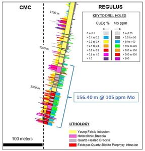
- The last 156.40 m of the hole runs 105 ppm Mo, suggesting we have may have entered the outer molybdenite (“moly”) shell of a porphyry center
John Black, Chief Executive Officer of Regulus, commented as follows:
“When we completed our resource update in 2019, the strip ratio was already attractively low at 0.85/1. The drilling completed recently to the north of the main resource to date, including Hole 52, is providing us valuable data that should allow us to grow the in-pit resource and convert areas treated as waste in 2019 to resources upon a new resource update. This should reduce the strip ratio even further. Hole 52 intersected several intervals of skarn mineralization that continue to demonstrate the skarn system is open to the north. Like nearby holes, recently completed Hole 52 intersected strongly fractured (“crackled”), silicified, quartz-healed and brecciated quartzites at depth that are locally well mineralized (>1% CuEq), despite quartzites typically being poor host rocks for mineralization. We also intersected numerous porphyry dykes of varying widths, which exhibit strong veining associated with chalcopyrite ± bornite mineralization, which is encouraging. Hole 52 provides more evidence there is a mineralizing source somewhere nearby. It could be below us, or laterally in any direction. More drilling will be required to search for the source.”
Dr. Kevin B. Heather, Chief Geological Officer of Regulus, commented as follows:
“Geologically speaking, Hole 52 is very complex and exhibits multiple, overprinting styles of mineralization, as is common in most large ore deposits. The upper portion of the hole consists of marble with incipient skarn development that progresses downhole into prograde skarn with locally developed massive magnetite-sulphide replacement bodies. This sequence is cross-cut by multiple, likely sub-vertical, gold-zinc±copper±lead intermediate-sulphidation (base-metal carbonate) veins and fault structures. Locally, these vein/fault structures can run multiple grams per tonne of gold across one-to-three-metre widths and can coalesce into much wider zones of ten’s of metres. The lower portion of the hole encountered very interesting silicified and quartz-healed breccias developed within the Farrat Formation quartzites that are cut by numerous feldspar porphyry dykes, all of which exhibit more classic porphyry style mineralization consisting of quartz-chalcopyrite-pyrite-molybdenite±bornite-anhydrite.”
Table 1 below provides more details on the mineralized intercepts encountered in AK-22-052. The location of the reported drill hole as well as active and completed holes are indicated in Figure 1. Figure 2 displays a cross section of AK-22-052. Figure 3 displays a closeup of the CuEq and Mo results found in the bottom portion of the hole.
| Table 1 – AntaKori Drill Hole Results | ||||||||
| From (m) | To (m) | Interval (m) | Cu (%) | Au (ppm) | Ag (ppm) | As (ppm) | CuEq (%) | |
| AK-22-052 | ||||||||
| Interval | 70.10 | 92.45 | 22.35 | 0.08 | 0.50 | 7.47 | 1,381 | 0.51 |
| Interval | 116.90 | 136.60 | 19.70 | 0.24 | 0.24 | 10.83 | 329 | 0.51 |
| Interval | 212.55 | 310.70 | 98.15 | 0.29 | 0.37 | 8.17 | 852 | 0.63 |
| incl | 291.80 | 303.40 | 11.60 | 0.70 | 1.19 | 33.41 | 5,181 | 1.86 |
| Interval | 332.30 | 344.50 | 12.20 | 0.39 | 0.12 | 7.70 | 169 | 0.55 |
| Interval | 650.75 | 782.50 | 131.75 | 0.17 | 0.21 | 4.42 | 538 | 0.36 |
| incl | 651.55 | 662.80 | 11.25 | 0.50 | 0.26 | 15.21 | 1,983 | 0.83 |
| Interval | 815.85 | 994.70 | 178.85 | 0.27 | 0.10 | 4.75 | 110 | 0.38 |
| incl | 815.85 | 866.05 | 50.20 | 0.45 | 0.18 | 6.99 | 355 | 0.64 |
| Interval | 1,010.75 | 1,038.85 | 28.10 | 0.13 | 0.07 | 2.77 | 119 | 0.21 |
| Interval | 1,098.00 | 1,385.80 | 287.80 | 0.39 | 0.06 | 3.18 | 756 | 0.46 |
| incl | 1,102.35 | 1,134.50 | 32.15 | 0.64 | 0.09 | 8.08 | 2,013 | 0.77 |
| and | 1,229.40 | 1,246.10 | 16.70 | 0.63 | 0.05 | 4.52 | 299 | 0.70 |
| and | 1,297.00 | 1,338.80 | 41.80 | 0.51 | 0.03 | 2.57 | 155 | 0.56 |
| and | 1,356.75 | 1,367.92 | 11.17 | 0.57 | 0.05 | 2.69 | 261 | 0.64 |
| and | 1,374.80 | 1,385.80 | 11.00 | 0.61 | 0.05 | 2.54 | 34 | 0.67 |
| The grades are uncut. Cu Eq and Au Eq values were calculated using copper, gold and silver. Metal prices utilized for the calculations are Cu – US$2.25/lb, Au – US$1,100/oz, and Ag – US$14/oz. All intervals presented above consist of sulphide mineralization. No adjustments were made for recovery as the project is an early-stage exploration project and metallurgical data to allow for estimation of recoveries is not yet available. The formulas utilized to calculate equivalent values are Cu Eq (%) = Cu% + (Au g/t * 0.7130) + (Ag g/t * 0.0091). | ||||||||
Discussion of Results
Drill hole AK-22-052 was drilled at an azimuth of 220 degrees and an inclination of -82 degrees.
Drill hole AK-22-052 starts with 1.20 m of overburden material prior to entering calcareous sedimentary rocks of Chulec Formation. From 1.20 m to 85.00 m, the hole encountered Chulec Formation massive and banded marble intervals with weak prograde garnet-vesuvianite skarn alteration and minor retrograde chlorite-pyrite-magnetite-chalcopyrite veins overprint. This skarn sequence is clearly overprinted by gold-zinc-silver ±lead ±copper intermediate-sulphidation (base-metal carbonate) veins and fault structures that are likely sub-vertical in geometry. These veins can run multiple grams per tonne gold and multiple percent zinc over one to three metres width and locally can coalesce into zones measuring several ten’s of metres in width. The mineralogy of this mineralization is dominated by sphalerite-galena-pyrite and likely other sulphosalt minerals.
From 85.00 m to 210.00 m, the hole intersected well-developed skarn intervals of Chulec Formation intercalated with semi-massive pyrite-magnetite-chalcopyrite skarn horizons. Skarn alteration in this zone is dominated mostly by prograde skarn alteration assemblages with garnet-vesuvianite, but some intervals are overprinted by massive retrograde epidote-chlorite skarn. Mineralization in this interval consists of traces of pyrite-chalcopyrite occurring as disseminations and veins associated with retrograde skarn alteration.
From 210.00 m to 338.05 m, the hole intercepted well-developed skarn intervals of Chulec Formation intercalated with semi-massive pyrite-magnetite-chalcopyrite skarn horizons. In this interval, retrograde epidote-chlorite skarn alteration is the dominant assemblage and becomes stronger at depth. Skarn mineralization in this interval is locally overprinted by 1-2 m width structures with chalcopyrite-sphalerite-galena base-metal carbonate mineralization that post-date the skarn alteration but increase the overall grade in those areas.
The contact with Inca Formation is found at 338.05 m and consists of intercalations of hornfels and retrograde chlorite-rich skarn horizons. Mineralization in this interval is generally weak and occurs as disseminations, veins, and massive magnetite-pyrite-chalcopyrite horizons with a notable increase of magnetite content compared to the overlying Chulec Formation skarn intervals.
From 415.40 m to 653.40 m, the hole encountered Farrat Formation quartzites and arkoses that are strongly fractured with quartz-pyrite veins and locally brecciated with the open spaces in the veins and breccias healed with drusy quartz and pyrite. This zone is cut by pyrite and molybdenite veins, as well as sporadic sphalerite-galena-pyrite-chalcopyrite base-metal carbonate veins. The last 50 m of the reported interval displays well-developed crackle-breccia textures and stronger pyrite mineralization within the quartzite host rock.
From 653.40 m to 782.50 m, the drill hole passes through a rhyolite intrusion with well developed flow-banding and auto-brecciation textures that are sub-parallel to the drill hole axis, indicating it is likely a sub-vertical intrusive body. The intrusion is affected by illite-kaolinite, quartz-sericite-pyrite alteration, with some chloritic alteration relics with complex overprinting textures. Mineralization in this interval has a gold-silver-zinc ±copper base-metal carbonate signature consisting of pyrite-chalcopyrite-tennantite-sphalerite-galena disseminations and veins.
A 50-metre interval of Farrat Formation quartzites is found at 782.50 m, prior to entering a major interval of feldspar-hornblende-biotite porphyry intrusion from 821.73 m to 1,297.00 m. This porphyry intrusion is affected by chloritic alteration overprinted by strong sericite-quartz-pyrite alteration which is associated with moderate to locally strong mineralization consisting of chalcopyrite-bornite-tennantite and galena-sphalerite occurring as disseminations and veins. This intrusion has local zones of abundant wall rock xenoliths, especially in the lower parts of the reported interval. These wall rock xenoliths include crackled quartzites and one 17-metre, clast-supported breccia interval, with high-grade pyrite-chalcopyrite-bornite-tennantite-enargite mineralization.
From 1,297.00 m to the end of the reported interval at 1,385.80 m, the drill hole intercepted an intercalation of strongly silicified, heterolithic, chaotic breccias developed within the Farrat Formation quartzites and arkoses that are cut by several feldspar-hornblende-biotite porphyry dykes that are affected by strong sericite-quartz-pyrite alteration and silicification. Mineralization in this interval is more classical porphyry style mineralization consisting of quartz-chalcopyrite-bornite-enargite-tennantite-anhydrite occurring as disseminations and veins. The last 156.40 m of this interval contains numerous quartz-molybdenite veins and averages 105 ppm Mo, which suggests we may have entered the outer molybdenite (“moly”) shell of a porphyry center.
Project Update
Hole AK-22-053 is complete and ended at 727.4 m with assays pending. This hole was completed on Colquirrumi ground where Regulus is earning up to a 70% interest. The goal of this hole was to add meterage towards the 7,500 m necessary to trigger the earn-in on Colquirrumi claims, and test for the eastern extension of mineralization. Hole AK-22-054 is in progress and testing the northern extension of mineralization on the property. At the time of this release, AK-22-054 was at approximately 900 m depth and AK-22-055 was just getting underway and is adding meterage towards the Colquirrumi earn-in, as well as testing for the extension of mineralization.
Upcoming Webinar
For more context, please join CEO John Black and Chief Geological Office Dr. Kevin B. Heather in a live event on Monday September 26th at 2 pm EST / 11 am PST. Q&A will follow the presentation. Click here to register: https://6ix.com/event/regulus-presents-corporate-update/.
Qualified Person
The scientific and technical data contained in this news release pertaining to the AntaKori project has been reviewed and approved by Dr. Kevin B. Heather, Chief Geological Officer, FAusIMM, who serves as the qualified person (QP) under the definition of National Instrument 43-101.
ON BEHALF OF REGULUS RESOURCES INC.
(signed) “John Black”
John Black
CEO and Director
For further information, please visit our website at regulusresoures.com or contact:
Ben Cherrington
Manager, Investor Relations
Phone: +1 347 394-2728 or +44 7538 244 208
Email: ben.cherrington@regulusresources.com
About Regulus Resources Inc. and the AntaKori Project
Regulus Resources Inc. is an international mineral exploration company run by an experienced technical and management team. The principal project held by Regulus is the AntaKori copper-gold-silver project in northern Peru. The AntaKori project currently hosts a resource with indicated mineral resources of 250 million tonnes with a grade of 0.48 % Cu, 0.29 g/t Au and 7.5 g/t Ag and inferred mineral resources of 267 million tonnes with a grade of 0.41 % Cu, 0.26 g/t Au, and 7.8 g/t Ag (independent technical report prepared by AMEC Foster Wheeler (Peru) S.A. dated February 22, 2019, see news release dated March 1, 2019). Mineralization remains open in most directions.
Sampling and Analytical Procedures
Regulus follows systematic and rigorous sampling and analytical protocols which meet and exceed industry standards. These protocols are summarized below and are available on the Regulus website at www.regulusresources.com.
All drill holes are diamond core holes with PQ, HQ or NQ core diameters. Drill core is collected at the drill site where recovery and RQD (Rock Quality Designation) measurements are taken before the core is transported by truck to the Regulus core logging facility in Cajamarca, where it is photographed and geologically logged. The core is then cut in half with a diamond saw blade with half the sample retained in the core box for future reference and the other half placed into a pre-labelled plastic bag, sealed with a plastic zip tie, and identified with a unique sample number. The core is typically sampled over a 1 to 2 metre sample interval unless the geologist determines the presence of an important geological contact. The bagged samples are then stored in a secure area pending shipment to a certified laboratory sample preparation facility. Samples are sent by batch to the ALS laboratory in Lima for assay. Regulus independently inserts certified control standards, coarse field blanks, and duplicates into the sample stream to monitor data quality. These standards are inserted “blindly” to the laboratory in the sample sequence prior to departure from the Regulus core storage facilities. At the laboratory samples are dried, crushed, and pulverized and then analyzed using a fire assay-AA finish analysis for gold and a full multi-acid digestion with ICP-AES analysis for other elements. Samples with results that exceed maximum detection values for gold are re-analyzed by fire assay with a gravimetric finish and other elements of interest are re-analyzed using precise ore-grade ICP analytical techniques.
Neither the TSX Venture Exchange nor its Regulation Services Provider (as that term is defined in policies of the TSX Venture Exchange) accepts responsibility for the adequacy or accuracy of this release.
Forward Looking Information
Certain statements regarding Regulus, including management's assessment of future plans and operations, may constitute forward-looking statements under applicable securities laws and necessarily involve known and unknown risks and uncertainties, most of which are beyond Regulus' control. Often, but not always, forward-looking statements or information can be identified by the use of words such as "plans", "expects" or "does not expect", "is expected", "budget", "scheduled", "estimates", "forecasts", "intends", "anticipates" or "does not anticipate" or "believes" or variations of such words and phrases or statements that certain actions, events or results "may", "could", "would", "might" or "will" be taken, occur or be achieved.
Specifically, and without limitation, all statements included in this press release that address activities, events or developments that Regulus expects or anticipates will or may occur in the future, including the proposed exploration and development of the AntaKori project described herein, the completion of the anticipated drilling program, the completion of an updated NI 43-101 resource estimate and management's assessment of future plans and operations and statements with respect to the completion of the anticipated exploration and development programs, may constitute forward-looking statements under applicable securities laws and necessarily involve known and unknown risks and uncertainties, most of which are beyond Regulus' control. These risks may cause actual financial and operating results, performance, levels of activity and achievements to differ materially from those expressed in, or implied by, such forward-looking statements. Although Regulus believes that the expectations represented in such forward-looking statements are reasonable, there can be no assurance that such expectations will prove to be correct. The forward-looking statements contained in this press release are made as of the date hereof and Regulus does not undertake any obligation to publicly update or revise any forward-looking statements or information, whether as a result of new information, future events or otherwise, unless so required by applicable securities law.
Figure 1 – Plan Map showing the location of drill hole collars and traces
Figure 2 – Cross Section displaying Hole AK-22-052
Figure 3 – Close up of CuEq and Mo results in bottom portion of AK-22-052. CuEq% (left), Lithology (center), Mo_ppm (right)
Graphics accompanying this announcement are available at
https://www.globenewswire.com/NewsRoom/AttachmentNg/84d5d7ef-8b4a-4ec9-8b6a-c502aae11a88
https://www.globenewswire.com/NewsRoom/AttachmentNg/f9df4a5e-7b64-428a-9b00-9ae24de7c876
https://www.globenewswire.com/NewsRoom/AttachmentNg/764c4686-6d1d-493a-855b-0a5f8968b9cf


Figure 1
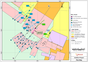
Plan Map showing the location of drill hole collars and traces
Figure 2
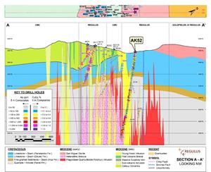
Cross Section displaying Hole AK-22-052
Figure 3